
Interesting Things
A Map is Never Neutral: How Cartographers Redrew the World
Meet the cartographers who wrestled with centuries of Western bias to redraw the map of the world. Discover how a single projection can reveal the hidden politics in geography and why understanding how we see the world is essential for navigating our own.
The Geometry of Power: Maps as Political Statements
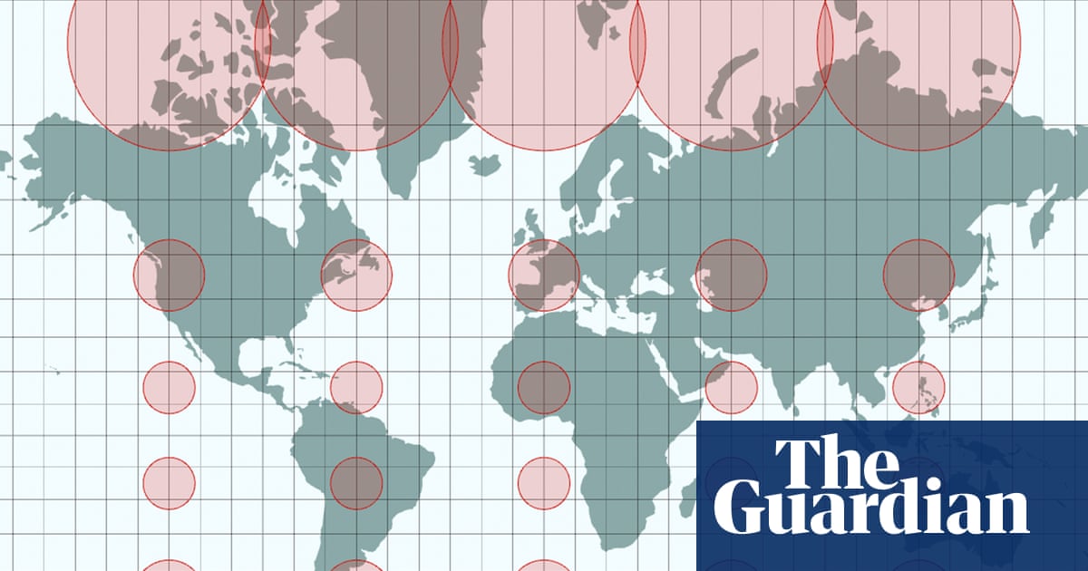
We often treat maps as windows onto objective reality, but the very act of drawing a map is an act of interpretation. The story of the Equal Earth projection forces us to look at this fundamental tension. Imagine trying to capture the curve of the Earth—a sphere—and force it onto a flat rectangle. As Bernhard Jenny noted, this process demands compromise; you have to 'tear and stretch' the reality, much like an orange peel, and that stretching inevitably distorts what we see. This is the core lesson: there are no neutral perspectives when mapping human experience.
The traditional Mercator projection has reigned for centuries, creating a world view where the North is always up, centering the map around Greenwich. This historical dominance subtly reinforced a specific, London-centric worldview, making northern nations appear disproportionately larger than they are in comparison to others. The cartographers who developed Equal Earth sought to dismantle this inherited bias, aiming instead for a representation that reflects the true relative sizes of landmasses, particularly Africa, without imposing artificial hierarchies.
The adoption of Equal Earth by the UN signals a significant cultural shift—a move toward acknowledging that geographical representation is not just science; it is politics. When nations vote to adopt a new map, they are voting on how they wish to be perceived in the global arena. The objections raised by some diplomats, such as Japan’s concern over the Kuril Islands or Ukraine’s abstention regarding Crimea, reveal that even mathematical projections become charged with geopolitical meaning. As one cartographer reflected, 'A map is never neutral.' This isn't just an academic footnote; it’s a profound commentary on how we construct and enforce boundaries in our world.
The Art and Science of Compromise
The journey to creating a more equitable map is less about finding a perfect truth and more about navigating necessary compromises. The backlash against earlier attempts, like the Gall-Peters model, which showed true relative sizes but often looked strangely elongated, demonstrates that every attempt to balance aesthetics with mathematical accuracy brings friction. Cartography, as Jenny argued, is both art and science—a delicate negotiation between what is mathematically possible and what is visually pleasing or politically acceptable.
The Equal Earth projection, while aiming for greater accuracy in continental sizing, still presents new challenges. As one cartographer noted, the resulting map might not be perfectly navigable; countries on the edges can appear squeezed, making navigation less intuitive than the familiar distortions of Mercator. This tension between mathematical fidelity and practical usability is a constant theme in mapping. It reminds us that any system designed to represent the world must balance scientific rigor with human perception.
The story of these cartographers—Patterson, Šavrič, and Jenny—is a powerful reminder that fundamental truths are often obscured by the frameworks we choose to use to see them. Whether dealing with the physical act of flattening the Earth or the political implications of drawing borders, the mechanism remains the same: compromise is unavoidable. The wonder lies not in finding a single, perfect map, but in recognizing the ongoing, necessary dialogue about what it means to represent the world honestly.
Why This Matters Now
Why should we care about how lines are drawn on a piece of paper? Because this exercise in cartography mirrors the larger human struggle with perspective and fairness. In our current climate, where global narratives are constantly being contested—whether over climate change, international relations, or social justice—understanding how we visualize space is crucial. If maps can be manipulated to reinforce existing power structures, then understanding the underlying mathematics of representation becomes a vital tool for critical thinking.
The concept that 'a map is never neutral' extends far beyond geography. It speaks to any system we use to organize information, allocate resources, or define social boundaries. When we look at how nations vote on projections, we see a microcosm of global politics playing out in the realm of visual representation. This realization encourages us to question the assumptions embedded in the systems we accept without scrutiny. It pushes us to seek out the 'center' and ask what is being left out, recognizing that the way we frame reality directly impacts our perception of power.
Ultimately, this exploration into cartography reminds us that true understanding requires humility. The cartographers’ struggle—balancing science, aesthetics, and politics—mirrors the complex work of navigating contemporary life. It invites us to approach the world not as a fixed, easily defined object, but as an ongoing, negotiated space, where every line drawn carries weight, and every perspective demands careful consideration before we accept it as absolute truth. The wonder is in recognizing the continuous effort required to map a reality that is inherently fluid.
The Cartographers' Legacy
Tom Patterson, who stepped out of retirement to engage with these complex issues, and his collaborators continue to push the boundaries of what maps can achieve. Their work, which seeks to integrate mathematical precision with geopolitical reality, offers a living document that is constantly being updated by feedback from governments and the public. This ongoing process demonstrates that understanding the world requires continuous engagement, not passive acceptance of established lines.
The legacy of this work lies in demonstrating that the pursuit of accurate representation is inseparable from the political realities of power. It shows that even in seemingly abstract fields like mathematics, the decisions we make about how to represent the world have tangible, real-world consequences for nations and communities. The ongoing dialogue surrounding projections like Equal Earth ensures that the conversation about spatial understanding remains dynamic and open to revision.
The work underscores a vital principle: true clarity is found not in finding a single, undisputed answer, but in embracing the necessary compromises inherent in human endeavor. By acknowledging that maps are living documents—constantly being revised based on new insights—we engage with the world with a more nuanced and curious awareness, recognizing the beautiful, messy reality of how we attempt to make sense of it all. It is an invitation to look closer at the lines we draw, and wonder about the space between them.
The Bigger Picture: Wonder in Complexity
This exploration into map-making connects to a broader sense of wonder about complexity. Just as the universe operates on principles that defy simple, flat visualization, our understanding of human society is similarly layered and multifaceted. The cartographers’ work suggests that the most profound truths are found not in simplistic, singular views, but in the intricate interplay between different viewpoints and the necessary compromises made to bridge them. This mirrors the way we process complex issues in life—acknowledging conflicting realities while striving for a shared understanding.
The mechanism at play is the tension between the ideal—a perfectly accurate, neutral map—and the reality of human limitations. We strive for an ideal that is both scientifically sound and aesthetically pleasing, but as Jenny pointed out, this pursuit inevitably leads to compromises. This mirrors the challenges faced by artists, musicians, and thinkers: balancing artistic vision with commercial demands, or scientific discovery with public acceptance. The wonder emerges from recognizing this dynamic tension; it’s in the negotiation itself that we find depth.
For the smart reader, the takeaway is a shift in how they view all systems of organization. Whether looking at global geography, economic data, or artistic expression, the lesson remains the same: systems are built by people, and therefore, they are inherently shaped by human concerns, biases, and desires. By understanding the mechanics behind how we map our world, we gain a deeper appreciation for the intricate, often contradictory, nature of human experience, fostering a more curious and thoughtful engagement with everything we encounter.
‘A map is never neutral’: meet the cartographers who took on centuries of western bias
It’s like the orange peel analogy,” said Jenny. “You have to tear it and stretch it, and it’s not possible to flatten it out … so you have to make compromises.”
‘Which way is up?’ or ‘Where is the centre’ are not simple questions for cartographers – ancient Islamic maps had a south-up orientation, which put the holy city of Mecca in the eyeline.
‘You have to make compromises,’ said Jenny.
Want our sources?
Enter your email and we’ll send the claim-linked sources used for this article.
We use this address only to send this source list.